
This page
Here in the "Big Walk" blog you can find all the diary entries written for the 2019 Walk to Wales. These are as they were written on each day of the walk, accompanied by the photos posted with each entry.
These entries have been moved to this page so that the front section of the blog can be re-used for new journeys.
What
This walk - codenamed the “Hinterland Walk” for reasons
which will become clearer later - is a 240-mile solo trek from my front door in
North London to the west Wales coast at Aberystwyth. The route quits London to
the northwest, crosses the Chilterns, some wild parts of Oxfordshire and the
Cotswolds before the half-way point in Worcester. The journey continues across Herefordshire,
then right across mid-Wales before landing at its destination.
When
The journey starts on Thursday 29thAugust 2019 and takes two weeks, including twelve days of travelling. The
timing is chosen to avoid peak holiday periods while still benefiting from relatively benign
weather.
How
The maths are simple – twelve days for 240 miles is an average
of 20 miles a day. Two rest days are built in – one in Worcester, one later,
deep into Wales. This is no rough trip – every night is in a B&B, a
pub, or an hotel, with decent food and a few drinks to round off the days. All
the same I do have to carry life’s essentials, so I have trained with a
backpack weight of around 10-11kg.
Why
The most difficult bit last! For peculiarly nerdy reasons
I have long had a fascination with the A44 road, which starts near Oxford and
ends at Aberystwyth. On the way it links some of England’s best, but least
well-known countryside, and ends with a crescendo as it crosses the quietly
wild parts of Wales. Some years ago I worked out a walking route which borrows
the direction of the road without following it exactly, but nothing came of it
until now.
There is no established long-distance walking route which
goes this way, and some large sections of the route are well off the tourist radar.
Just Google “walk from London to West Wales” and nothing will come back that
hints at this route. That alone is enough reason to give it a try.
I know that doesn’t really answer the question, but I
hope it helps.
Inspirations
For walking in general I draw much inspiration from the
writings of John Hillaby, one of Britain’s less obvious pedestrians. His “Journey
through Britain” (1968) describing an off-road walk from Land’s End to John O’Groats,
is very much in the background of this journey. Likewise George Borrow’s “Wild
Wales”, published in 1862, which describes a series of journeys on foot through
Wales in 1854. Borrow’s chronicles are excellent descriptions of the Wales of
the time, as long as you can see past the man’s rather pompous approach. It’s
no accident that one of my stopovers is the George Borrow Hotel in Ponterwyd,
just before descending to the coast.
Getting ready
Although I have been a keen walker for years I needed to
prepare for the daily distance. Once again, there is no one simple guide to how
to train for such a trek. From January onward I gradually increased my walking
distances, and from the end of May I added a loaded pack. Along the way I have
tested and refined choices of footwear, clothing and other gear; an important
but expensive process.
I also discussed the exploit with my GP, given that I’m a
few weeks past my 70th birthday. She told me to get on with it and
enjoy it. Thank you, ma’am,…
This blog
This is a diary of the journey.
Various friends wanted photos, WhatsApp updates and whatever – here it can all
be in one place. Unlike
this piece, written on a PC in the comfort of my home office, travel entries
rely on a phone and some ingenuity!
Hinterland
No secret. “Hinterland” was a short-lived but engaging TV
detective series filmed in and around Aberystwyth. That, and the simple fact
that this route avoids the most obvious and popular destinations is enough
justification for the codename.
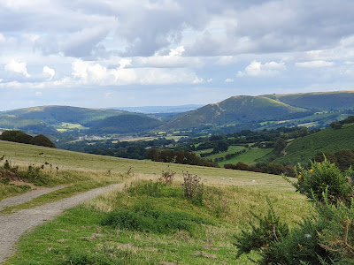
Almost ready...26th August

I do have to confirm that I can stay standing up though – a fall a few days ago left me with a beautiful black eye. This happened close to where the picture was taken - the serenity is deceptive!
I have been asked whether this is a sponsored walk, and whether it follows a predefined long-distance walking route. No to both. The route is entirely my own, although it uses short sections of several long-distance paths along the way. No-one else has so far been mad enough to go this way, it seems.
Day One - Finchley to Watford - 29th August
And what a good day to get started! The weather was benign, sunny and not too hot all day. I was blessed with a great bacon sandwich to kick off the journey (thank you Sue) and a lovely send-off with the neighbours. After the first mile I was joined for the rest of the day by old friend Alan, worthy company on the route
And what of the route? Well-trodden ways out of Finchley, paths regularly used on training walks, then a dreary section of main roads. Suddenly then we came on a footpath near Elstree which clearly isn't much walked - it was a good adventure...
Lunch at Aldenham Country Park, then by Elstree Aerodrome (duck!!) before dropping into Bushey. We refreshed with a welcome pint before the end of the route, not the loveliest part of Watford, but, well, the end of the day.
My Premier Inn room is a comfortable surprise, so I'm looking forward to a good night before a rather longer trip tomorrow.
First though, something and chips in the Brewers Fayre next door. Luvly!


More sunshine, and 24 miles to soak it up...


Day four - Hampton Poyle to Chipping Norton - 1st September
So here was a day which started brilliantly, with sunshine in clear blue skies, and just warm enough for walking in comfort.
I filled up on a copious breakfast, then left the Bell Inn and headed by Hampton Poyle's little church on to paths across very green meadows. The walk to Shipton-on-Cherwell goes past the church of Hampton Gay (no comments please), accessible more or less only on foot.

A couple of miles further is the neat little town of Woodstock. Thank goodness it has a Coop supermarket open all day on Sundays, as this is the last town or village for 14 miles on my route.
Woodstock is the gateway to Blenheim Palace, and I had planned to follow paths through the park, with glimpses of the palace and of the Column of Victory.


You might think the Blenheim Estate would tend its footpaths carefully. You'd be mistaken. I got through thanks to heavy use of GPS!
Much of the day was spent on an old drove road called the Salt Road, which cuts a near-straight line across the Oxfordshire landscape. I followed it for about ten miles in all, and saw hardly a soul. It rained briefly but vigorously - leaving me wondering how a 9% chance of rain, according to the forecast at 9am, could morph into 67% four hours later... But soon the sunshine returned, and the afternoon was warm and friendly.


Close to destination I found myself on a delightful meadow path, quintessential English country walking. This is, I thought, what this journey is all about. The sheep guarding one footbridge seemed to agree.

Journey's end today is my second Premier Inn, a very new hotel on the edge of Chipping Norton. This little old town really is where the journey across the Cotswolds begins - it's also the first place in which signs for the A44 appear, as mentioned in an earlier post.
Just over 18 miles today, almost relaxing compared with the previous two days. I think my legs and feet have got the message now - no point complaining, we're going to keep on travelling... So far they are behaving well.

I
confess to sipping my second pint as I write up the day - just washing
down some great fish and chips in a friendly pub in Broadway.
I also confess that it took a little effort to separate body and bed this morning, after a good night's sleep. I left Chipping Norton just before 9am, in bright clear sunshine. It was cool, but a few minutes on the way soon got my muscles warmed up.
Today was a trek through lesser-known villages, avoiding the tourist hotspots along the A44. First came Salford, where I think everyone was still asleep...

Next, after a wander along an old track way and a climb over a hill crowned by an ancient hill fort (and lots of cowpats) was Chastleton, dominated by its stately house (closed Mondays and Tuesdays...).

More old trackways led to Evenlode, currently dug up by Thames Water, but with enticing views along the way.

Then a long gentle climb over fields to Longborough. Half way through the day's journey, and blessed with the Coach and Horses pub. I was a little put off by the crowded outside space, but inside was peaceful. The perfect spot to enjoy a massive ham and mustard doorstop and a pint of local bitter.
From Longborough there's a long climb, then undulating delightful paths through to the isolated manor house at Hinchwick.

There began a strange experience. I followed a bridle way through a long and twisting valley. It is more than 2 miles long, there are no habitations or buildings, and not another soul in sight. To add to the atmosphere the sky turned grey and threatening, and hawks of some kind (I'm not good with bird ids) circled above. Vaguely unsettling, but fascinating.


Beside
a meadow a little further on I rested and celebrated roughly 100 miles
since leaving Finchley. The highest point of the route so far, around
930ft, came up at a bleak crossroads just before the sweet little
village of Snowshill.

From here the scenery went into overdrive. The path dropped and climbed again in steep undulations, but every huff and puff was rewarded with a new vista.


Confidence is also helped by good route marking, as this section was part of the Cotswold Way national trail. In fact today's route has been good for routefinding, only one ploughed field and two confusions!
At last the path descends, with a view ahead of Broadway.

It's a tourist honeypot, as witness the heaving crowded gastro-pub just nearby - heaving and crowded despite charging a minimum of 18 quid for a main course. Which is why I ended up in the Crown and Trumpet. That second pint is almost gone, time to put this post to bed!

Day six - Broadway to Worcester - 3rd September


I
knew the last nine miles wouldn't hold too much attraction. What I
didn't expect was that Worcestershire County Council would trump all the
ploughed-up paths I'd met so far by completely digging up a whole
section of the route, without prior warning. Something to do with a new
ring road. You have to love the phrase "no alternative route available".
What I really didn't need was a long and boring diversion at the end of
a leg-stretching day. Thanks guys..
But hey, here we are in Worcester, with a rest day to come tomorrow. Around 26 miles today, and now, at about 128 miles, just a touch over half way. No excuses for not carrying on then!

Day seven - Worcester - 4th September
A rest day in Worcester, a brief chance to get my legs into gear for the second half of the journey. While the mileage from here is just a little less than already travelled, the terrain will be rather more interesting.
Time here shared with my wife, today also with friends - and blessed with sunshine.
Just a very brief post for now, more to follow tomorrow and beyond.


Almost ready...26th August
This page and my feet, that is. This piece is written three days before the off.
Training is almost at an end: I have one more walk planned before setting off, just to keep the engine in tune. I’m reasonably satisfied, having averaged around 70 miles a week, with full pack, for several weeks, peaking at 93 miles. There isn’t so much left to prove. I remain apprehensive about averaging 20 miles a day, day after day, but I’m confident…
Training is almost at an end: I have one more walk planned before setting off, just to keep the engine in tune. I’m reasonably satisfied, having averaged around 70 miles a week, with full pack, for several weeks, peaking at 93 miles. There isn’t so much left to prove. I remain apprehensive about averaging 20 miles a day, day after day, but I’m confident…

I do have to confirm that I can stay standing up though – a fall a few days ago left me with a beautiful black eye. This happened close to where the picture was taken - the serenity is deceptive!
I have been asked whether this is a sponsored walk, and whether it follows a predefined long-distance walking route. No to both. The route is entirely my own, although it uses short sections of several long-distance paths along the way. No-one else has so far been mad enough to go this way, it seems.
Day One - Finchley to Watford - 29th August
And what a good day to get started! The weather was benign, sunny and not too hot all day. I was blessed with a great bacon sandwich to kick off the journey (thank you Sue) and a lovely send-off with the neighbours. After the first mile I was joined for the rest of the day by old friend Alan, worthy company on the route
And what of the route? Well-trodden ways out of Finchley, paths regularly used on training walks, then a dreary section of main roads. Suddenly then we came on a footpath near Elstree which clearly isn't much walked - it was a good adventure...
Lunch at Aldenham Country Park, then by Elstree Aerodrome (duck!!) before dropping into Bushey. We refreshed with a welcome pint before the end of the route, not the loveliest part of Watford, but, well, the end of the day.
My Premier Inn room is a comfortable surprise, so I'm looking forward to a good night before a rather longer trip tomorrow.
First though, something and chips in the Brewers Fayre next door. Luvly!

Along the Dollis Valley Greenwalk


Aldenham Country Park
Day Two - Watford to Longwick - 30th August

I forgot yesterday to post the map of the route for the day, so here it is...

And here is today's little jaunt...

Getting
out of Watford was a similar slightly scruffy experience to getting in,
but soon the countryside arrived. Crossing the M25 I celebrated finally
quitting London!
From
here I took the Chess Valley Walk route all the way to Chesham. The
route is sometimes path, sometimes a collection of signposts, but the
second part around and beyond Latimer was very pleasant. If very up and
down. Ascent and descent have been a feature all day - this section
totals 2,300 feet of uphill...


Out
of Chesham (up a steep hill) I soon picked up a long and isolated track
through the improbably named valley of Herbert's Hole (picture below),
then gave in to roads to reach Great Missenden.

A good job I hadn't been counting on it, because it seemed closed. All of it. On a Friday afternoon. Only the slightly weird Roald Dahl museum was open, selling vastly overpriced soft drinks. I paid up...


A good job I hadn't been counting on it, because it seemed closed. All of it. On a Friday afternoon. Only the slightly weird Roald Dahl museum was open, selling vastly overpriced soft drinks. I paid up...

Outside
the village is the house where Dahl lived, now carefully hidden behind
walls and hedges, then (at the top of a very steep hill) the delightful
Angler's Spring Wood, apparently a favourite strolling ground of the
author. At the end of the trees I met a very well-spoken lady picking
blackberries. She asked me where I was off to, so purposefully? She
hadn't quite bargained for the answer!
On
then through Prestwood and across totally deserted field paths to
Hampden House and church, handsome both, and well off the beaten track.

Onward through equally deserted and slightly spooky woodland to Whiteleaf Hill, highest point on the route so far. Crossing the Ridgeway path here meant I had done it. I'd crossed the Chilterns.

A knee-crackingly steep descent to Monks Risborough and a mile or so of tedious roads brought me to my overnight stay, a luxury farm b&b with a 9.8 Booking.com rating. We shall see. No evening food, but I ended the day with fish and chips and a pint in the local pub.
Do
my legs ache? Just a bit, but nothing that won't be OK after a night's
rest. They have no choice but to be ready for tomorrow. Day three is
about the same distance as today, but with less than half the ups and
downs. And my hosts here have promised a very good breakfast to set me
on my way.
Day Three - Longwick to Hampton Poyle - 31st August
I didn't have very high hopes for this day. I knew that much of it wouldn't be very scenic, especially compared to the previous day, and that, at 23 miles or so, it would be long. I wasn't much disappointed!
After a good breakfast and a long chat with my host I set off for Thame. That first seven miles wasn't so bad, and in Thame, a fairly neat little town, I knew I would pass a Waitrose, perfect for lunch and restocking. It was after then that things went a little downhill. Paths weren't easy to find, and if they could be found they weren't pleasant. After wading through miles of undergrowth and slogging across a bald ploughed field I switched to the roads, never mind the boredom, it would help make up for lost time.

I walked on roads for about six miles, ducking villages and crossing the M40, before risking paths again. My enduring memory will be a little sign asking walkers to "please keep to the path", pointing at a path long since lost to nettles, brambles and waist-high grass. And to add to the fun, it rained. Not for long, but with some vigour, it rained. Defeated by yet another ploughed field where the farmer hadn't bothered to put the path back, I made a diversion to reach the delightful little village of Beckley.


From here, and with the sun back on form, the day rapidly improved. The last half-dozen miles redeemed all that had gone before. I followed the Oxfordshire Way down to the edge of Ot Moor, and on to Noke and Islip.
Ot Moor is a weird anomaly in the middle of Oxfordshire. A level marshy empty expanse, boggy in places, it is the strangest thing to come across in an otherwise fields-and-woods English landscape. When the M40 was built, it took a major protest to stop the motorway being driven right through the moor. Today the fight is to prevent a new Oxford/Cambridge expressway doing exactly the same.

And so to Hampton Poyle, which you can be forgiven for never having noticed. It's home to the Bell Inn, which tonight is very busy despite its expensive beers and food. What the hell, after today I deserve an indulgence!
Day three was also always going to be a physical test. I had done two long days back to back, but never three. Of course there is some soreness, but not really any worse than after day two. I started out feeling a little fatigued but soon got over that and I have no trouble with the feet, although they keep on taking a bashing. I'm very consoled that the day went well overall, and ready for day four. Over 65 miles so far, less than 180 to go now. Subject to no more trouble with Oxfordshire footpaths tomorrow is shorter, at 19 miles. A walk in the park...

Day four - Hampton Poyle to Chipping Norton - 1st September
So here was a day which started brilliantly, with sunshine in clear blue skies, and just warm enough for walking in comfort.
I filled up on a copious breakfast, then left the Bell Inn and headed by Hampton Poyle's little church on to paths across very green meadows. The walk to Shipton-on-Cherwell goes past the church of Hampton Gay (no comments please), accessible more or less only on foot.

A couple of miles further is the neat little town of Woodstock. Thank goodness it has a Coop supermarket open all day on Sundays, as this is the last town or village for 14 miles on my route.
Woodstock is the gateway to Blenheim Palace, and I had planned to follow paths through the park, with glimpses of the palace and of the Column of Victory.


You might think the Blenheim Estate would tend its footpaths carefully. You'd be mistaken. I got through thanks to heavy use of GPS!
Much of the day was spent on an old drove road called the Salt Road, which cuts a near-straight line across the Oxfordshire landscape. I followed it for about ten miles in all, and saw hardly a soul. It rained briefly but vigorously - leaving me wondering how a 9% chance of rain, according to the forecast at 9am, could morph into 67% four hours later... But soon the sunshine returned, and the afternoon was warm and friendly.


Close to destination I found myself on a delightful meadow path, quintessential English country walking. This is, I thought, what this journey is all about. The sheep guarding one footbridge seemed to agree.

Journey's end today is my second Premier Inn, a very new hotel on the edge of Chipping Norton. This little old town really is where the journey across the Cotswolds begins - it's also the first place in which signs for the A44 appear, as mentioned in an earlier post.
Just over 18 miles today, almost relaxing compared with the previous two days. I think my legs and feet have got the message now - no point complaining, we're going to keep on travelling... So far they are behaving well.

Day five - Chipping Norton to Broadway - 2nd September
I also confess that it took a little effort to separate body and bed this morning, after a good night's sleep. I left Chipping Norton just before 9am, in bright clear sunshine. It was cool, but a few minutes on the way soon got my muscles warmed up.
Today was a trek through lesser-known villages, avoiding the tourist hotspots along the A44. First came Salford, where I think everyone was still asleep...

Next, after a wander along an old track way and a climb over a hill crowned by an ancient hill fort (and lots of cowpats) was Chastleton, dominated by its stately house (closed Mondays and Tuesdays...).

More old trackways led to Evenlode, currently dug up by Thames Water, but with enticing views along the way.

Then a long gentle climb over fields to Longborough. Half way through the day's journey, and blessed with the Coach and Horses pub. I was a little put off by the crowded outside space, but inside was peaceful. The perfect spot to enjoy a massive ham and mustard doorstop and a pint of local bitter.
From Longborough there's a long climb, then undulating delightful paths through to the isolated manor house at Hinchwick.

There began a strange experience. I followed a bridle way through a long and twisting valley. It is more than 2 miles long, there are no habitations or buildings, and not another soul in sight. To add to the atmosphere the sky turned grey and threatening, and hawks of some kind (I'm not good with bird ids) circled above. Vaguely unsettling, but fascinating.


From here the scenery went into overdrive. The path dropped and climbed again in steep undulations, but every huff and puff was rewarded with a new vista.


Confidence is also helped by good route marking, as this section was part of the Cotswold Way national trail. In fact today's route has been good for routefinding, only one ploughed field and two confusions!
At last the path descends, with a view ahead of Broadway.

It's a tourist honeypot, as witness the heaving crowded gastro-pub just nearby - heaving and crowded despite charging a minimum of 18 quid for a main course. Which is why I ended up in the Crown and Trumpet. That second pint is almost gone, time to put this post to bed!

Day six - Broadway to Worcester - 3rd September
Sixth
day... After yet another large breakfast I pointed my legs out of
Broadway, to start what was always planned as a long trek. The first
section was across unremarkable flat countryside, so I switched away
from a random selection of footpaths and took to the roads to gain some
time. Eight miles in, I passed through the thatchy village of Elmley
Castle, and started the climb up Bredon Hill. It's not hard to find -
"Hill Lane" gets steeper until it gives way to bridleways... The climb
is quite relentless but the views just keep getting better.


Cresting
the ridge at the top of the hill the hard work eases, and it's a gentle
stroll to the Banbury Tower, otherwise known as Parson's Folly, built
in the mid-18th century for local MP and squire John Parsons.

Rather
like the tower on Leith Hill in Surrey, it squeezes the natural summit
height of 981ft to just over the magic 1000ft. And today it's graced
with a mobile phone booster...
The views extend east back to the Cotswold ridge, and west to the Malvern Hills.


From the summit I dropped down to pass Woollas Hall, a rambling mansion built in 1611 and much extended in the 18th century.
There's
a family connection - my maternal great-grandparents were in service
here in the 1890s, great-grandfather as a gardener, his wife as a
ladies' maid, and much of my grandmother's young life was spent nearby.
Today, inevitably, the old house is converted into luxury flats.

Onward to Great Comberton, and a brief dalliance with "Shakespeare's
Avon Way" (nice idea, shame about the absent waymarking) brought me to
the neat Georgian town of Pershore, its attraction sadly defiled by
parked cars everywhere. I took lunch sitting opposite the abbey then
set off for the final stage to Worcester.

But hey, here we are in Worcester, with a rest day to come tomorrow. Around 26 miles today, and now, at about 128 miles, just a touch over half way. No excuses for not carrying on then!

Day seven - Worcester - 4th September
A rest day in Worcester, a brief chance to get my legs into gear for the second half of the journey. While the mileage from here is just a little less than already travelled, the terrain will be rather more interesting.
Time here shared with my wife, today also with friends - and blessed with sunshine.
Just a very brief post for now, more to follow tomorrow and beyond.


Day eight - Worcester to Bromyard - 5th September
Not only was yesterday a rest day, but today's distance was quite moderate, at 17 miles, so there was no need to race out of Worcester. The weather threatened a little, but eventually it decided to abide by the forecast, and the sun came out once more.
About an hour in, I reached the birthplace of composer Edward Elgar. The National Trust has done a good job here, with a well-presented little museum across the way from "The Firs", the cottage of Elgar's birth. Apparently the family moved when Edward was only two, so he would not have remembered much of his early life there, but he did visit regularly later. The cottage is cosy, and worth a visit. Needless to say, there is also a cafe and shop on site.

From there my route took me across rolling country, with some good retrospective views of the Malverns, before climbing steeply through woods to Ankerdine Hill.


A sharp descent, worthy of the Chilterns, led me to the Talbot Inn, beside the river Teme.

No worries about beer deliveries here - the Teme Valley Brewery is right behind the pub, and their ale is very good indeed. So is the pub grub.
The afternoon worked off my lunch very well, it felt like one long uphill, although in truth there were some downhills too. The scenery, by now in warm sunshine, displayed England's rural best.


Interesting though that in more than seven miles there were no villages. Hamlets and big farms yes, but nothing resembling a village.
I went through a couple of footpath confusions and half a mile of nasty tall bracken but finally reached Bromyard Down. From the 700ft-high road there was an enticing westward view revealing, in the very far distance, the line of the Welsh hills. Soon to come...

My overnight is in the old town of Bromyard, much of which has survived since the 16th century, including my half-timbered bedroom in a half-timbered hotel.
Herefordshire at last, a county which even puts a cider apple emblem on its wheelie bins... There is only the conversation in the hotel bar to remind me that this is still the Midlands!
It will take another day and a half to cross it, then comes Wales.

Day nine - Bromyard to Shobdon - 6th September
Friday
- today - began grey, windy and distinctly chilly in Herefordshire.
Stung by so many poor footpaths I shunned my original route plan and
stuck to the roads out of Bromyard for the first couple of miles to the
settlement of Edwyn Ralph. Just as well - the end of the path where I
would have hoped to rejoin the road was missing under a full crop of
maize!
Not so the next path option which stuck to a good farm track, gently climbing to a ridge which offered a final farewell view of the Malverns.
Not so the next path option which stuck to a good farm track, gently climbing to a ridge which offered a final farewell view of the Malverns.


My
westward trudge stayed with that ridge, following narrow lanes between
isolated settlements - another day with few villages. In the straggling
hamlet of Hatfield (sorry, no Galleria here...) it was quite a surprise
to find an old school house, now a private residence. The catchment area
might have been interesting!

Two
more poor footpaths, one necessitating a mile-long diversion, the other
forcing me to walk half a mile on the busy A44, and I arrived in
Leominster (pronounced "Lemster"). Another day, another Georgian town,
although this one is more workmanlike and less ostentatious than, say,
Pershore. I took a quick lunch and headed on.
Here's a street name that caught my eye on the way out of town. Somehow appropriate...

Here's a street name that caught my eye on the way out of town. Somehow appropriate...

By
now the doom and gloom in the weather forecast had failed to arrive,
the sun was out and the day was warming up. Once again I spurned
footpaths for roads, again my caution was justified when I saw what some
of the paths were like.
At last a village - Kingsland rambles on for about a mile, but it does proudly display the local love of half-timbering.


At last a village - Kingsland rambles on for about a mile, but it does proudly display the local love of half-timbering.


From
here it was a short (but steep) trot to my destination, the village of
Shobdon. With time to spare before checking in I walked the half mile up
through the Shobdon estate to the church.


Its
plain exterior apparently hides an extravagant interior in "Strawberry
Hill Gothic" style modelled on the work of Horace Walpole at his London
house. I say apparently because today the church was firmly locked.
It was built in 1756 by the Bateman family, owners of the estate. They took the Norman Romanesque arches of the previous church, dating from 1130, and put them together further up the hill behind their new church. Shobdon's "arches" are an unusual curiosity.

It was built in 1756 by the Bateman family, owners of the estate. They took the Norman Romanesque arches of the previous church, dating from 1130, and put them together further up the hill behind their new church. Shobdon's "arches" are an unusual curiosity.

My hostelry here takes the family name, Bateman, so clearly a long-standing watering hole. And so far well worth a pause here.
Onward tomorrow to Kington, then over the hills into Wales, finally justifying the name of this blog...

Onward tomorrow to Kington, then over the hills into Wales, finally justifying the name of this blog...

Day ten - into Wales - Shobdon to Radnor - 7th September
A
very comfortable night in Shobdon, the Bateman Arms gets my
recommendation. Onward then towards Kington, 9 miles away. From a scenic
point of view I had low expectations of the first few miles, and I
wasn't disappointed. Then I discovered little Noke Lane. This very
narrow strip of tarmac with grass in the middle wanders up and down for
about three miles, truly not the beaten track, and quite delightful.

I reached the little town of Kington, last corner of England, and a walkers' mecca as it sits astride the Offa's Dyke National Trail. The architecture isn't red brick any more, here begin the white walls and black window frames more familiar in Wales. There's a Welsh lilt to the accent here too, even in the Co-op supermarket where I bought some lunch.
The Offa's Dyke path leaves the town up a long straight hill, eventually opening on to heathland and rising gently but insistently on to Hergest Ridge. Apart from the musical connection, this rounded 1,400ft lump shows the remnants of a Victorian racecourse, and displays improving views as height is gained.

It's also inevitably popular, and today it was quite busy. At least on the English side. It turned grey and rained lightly for just a few minutes.
I paused for a moment's celebration where the GPS told me I'd reached the Welsh border. Croeso I Gymru! No passport required, not for now at least...
On the Welsh side the sun came out. I think I'd treat that as unusual... But the views at this point just got better and better, stretching southward to the Brecon Beacons and the Black Mountains, and westward revealing a patchwork of fields and hills.


I left the National Trail behind at the hamlet of Gladestry, at the end of a long descent from the ridge.

What goes down must go up again, for the last five miles or so of the day, this time on lanes and tracks climbing to the side of Burl Hill, and on up and up to 1,400ft, roughly the same altitude as the top of Hergest Ridge.


Then came a gentle descent, with views of the hills of Radnor Forest ahead.

My bed for tonight is in an ancient inn, still 1,200ft up, alongside the A44 at one of its most scenic points. It's cosy, the beer and food is good, what's not to like?
It has been a tough day for ups and downs (about 2,500ft of them) if only around 20 miles in distance, but so rewarding.


A little further on I took to a stony track which climbs eastward towards Plynlimon. It was very quiet up there, even the sheep had little to say.


After about a mile and a half the track passed three little lakes, then turned south. In front were the crags which tumble from Plynlimon's summit, with a small lake at their foot, from which the river Rheidol starts. I turned back about 200 yards from the lake itself as the track was flooded knee-deep, but the setting was impressive enough.


Day fourteen - Ponterwyd to Aberystwyth, journey's end - 11th September


And buried down in the town there are now some great independent shops and a string of adventurous places to eat. In some ways it's still old-fashioned seaside, and the beach is uninviting granite grey sand, but it's worth a visit.
Perhaps not over 240 miles on foot though...
As to the journey. Was it worth it? You bet. What an experience! Obviously I've seen places which can only be discovered on foot, and I've watched the landscape gradually change along the way. It's sometimes been tough, sometimes frustrating, but mostly just amazing. I'll not easily forget the Chilterns, the Cotswold tops, the huge vistas from Bredon Hill, Hergest Ridge, or the drove roads around Radnor. Even the Cambrian wildernesses in the rain.
I've been asked if it was lonely: I'd rather call it solitary, occasionally daunting, all in a positive way.
Physically - by the time I reached the end I could have gone on and on. The thought of getting out of bed for another 20 miles with a full pack was no longer any concern. I feared I might have to worry about legs and feet - especially feet - but I had no problems.
Would I do it again? Not the same route, no, but a similar trek, yes. Not straightaway, these things take a long time to plan. For now I'll be happy to keep up a decent weekly rate, perhaps 50-60 miles a week, just to maintain the engine.
Just not over the next few days, which are earmarked for serious indulgent relaxation.
In the next week or so I'll check the exact route I followed, rather than the one I planned, to confirm the actual distances and ups and downs.
And there may well be more thoughts to come on here... Stats and stuff
I reached the little town of Kington, last corner of England, and a walkers' mecca as it sits astride the Offa's Dyke National Trail. The architecture isn't red brick any more, here begin the white walls and black window frames more familiar in Wales. There's a Welsh lilt to the accent here too, even in the Co-op supermarket where I bought some lunch.
The Offa's Dyke path leaves the town up a long straight hill, eventually opening on to heathland and rising gently but insistently on to Hergest Ridge. Apart from the musical connection, this rounded 1,400ft lump shows the remnants of a Victorian racecourse, and displays improving views as height is gained.

It's also inevitably popular, and today it was quite busy. At least on the English side. It turned grey and rained lightly for just a few minutes.
I paused for a moment's celebration where the GPS told me I'd reached the Welsh border. Croeso I Gymru! No passport required, not for now at least...
On the Welsh side the sun came out. I think I'd treat that as unusual... But the views at this point just got better and better, stretching southward to the Brecon Beacons and the Black Mountains, and westward revealing a patchwork of fields and hills.


I left the National Trail behind at the hamlet of Gladestry, at the end of a long descent from the ridge.

What goes down must go up again, for the last five miles or so of the day, this time on lanes and tracks climbing to the side of Burl Hill, and on up and up to 1,400ft, roughly the same altitude as the top of Hergest Ridge.


My bed for tonight is in an ancient inn, still 1,200ft up, alongside the A44 at one of its most scenic points. It's cosy, the beer and food is good, what's not to like?
It has been a tough day for ups and downs (about 2,500ft of them) if only around 20 miles in distance, but so rewarding.

Day eleven - Radnor to Rhayader - 8th September
I
woke to blue skies and brilliant views - although apparently outside it
was downright cold. Breakfast was enormous. My host explained that he
was determined to send me off for the day well sated.
Today was pretty much all westward, over the hills to Llandrindod Wells, then over more hills to Rhayader. Only 18 miles in plan, but over 2,500ft of ups and downs.
Mist hung in the valleys below Radnor first thing, but it quickly burned off.

My route to Llandrindod, or Llando as the locals call it, used old drovers' roads to climb away from the A44, the views getting better and better as height was gained.


This is very much sheep country. Although they're generally charming creatures, they're indiscriminate when it comes to defecation, so walking here is a constant dance of avoidance.
The route climbed to 1,400ft by Pawl Hir hill, before making a steep and sometimes slippery descent towards Llandrindod Wells. I've been here before on a Sunday, so I was ready for its funereal silence.
Out of town to the village of Llanyre the local authority kindly provides a long cycle/pedestrian path to avoid a quite nasty stretch of main road. This is a good step up from some parts through which I've travelled. I felt the same as I started out on the next footpath of my route, as it seemed well-signposted and provided with stiles in all the right places. It climbed very (very) steeply across fields (more sheep) once again with ever-growing views.


Despite my reluctance to commit to footpaths based on experience across all those English counties, this one represents a fairly direct line between Llandrindod and Rhayader, so I reasoned it should have been OK. Right up to the top of Rhiw Gwraidd, once more 1,400ft and crowned with a small TV mast, it worked well.
Then, at the first stile of the descent, it all went pear-shaped. A third of a mile of tall bracken. There were bits and pieces of a line through it, then nothing. But there was no going back and no useful alternative route. I found the next stile with the help of some precise GPS, then relaxed as the path recovered in a little wood. Too fast! Next came bogs, and another wood which had been more or less chopped down, meaning no path, just masses of cut timber. Eventually I found a forest track to make an escape. The next five miles into Rhayader were thankfully unremarkable, save for more good views approaching the little town.


It has been a great day for scenery, and good for sunshine. Tomorrow's forecast is simply dire, but at least it should test my raingear...

Day twelve - Rhayader to Ponterwyd - 9th September
It
had to happen - a wet day. I left Rhayader in grey miserable drizzle,
kitted out in all my waterproof gear. That rather pricey selection was
the result of hours of research, so at least I'd find out if it
worked...
My planned route went north on little lanes to Llangurig (the A44 again) then west on footpaths and woodland tracks. No. Not in the rain. I set off on the alternative roads-only route, going over the moors to Cwmystwyth, then on to Devil's Bridge and so to Ponterwyd. Cwmystwyth was 14 miles away, with nothing much in between, so the only way was to set my head for around 4.5 hours of walking and...just do it.
Out of Rhayader the road climbs relentlessly to its highest point, at 1,582 feet (also the highest point of my route)

before dropping into the head of the Elan Valley, where it meets the tourist road coming up past all those reservoirs.

A road sign simply announces "Aberystwyth by mountain road". Yep. That's the one. The road narrows and climbs gently, following the Elan river up to the huge bog in which it rises - in truth the starting point for much of Birmingham's water.

The drizzle had stopped, but it looked very threatening ahead. As I crossed the watershed between the Elan and the Ystwyth rivers, it poured. Not for too long, but unpleasant enough.
Having said that, walking alone in that wild place with hardly anyone else in sight - in all 14 miles I saw only about thirty vehicles - was a rather surreal experience. There was also zero mobile signal, so not a good place to get into trouble!
The gear test was going well. Underneath all that wetness I was warm and dry.
On a better day I reckon the Ystwyth valley would be stunning. Even in the grot, it was five miles of impressive scenery.


As I neared Cwmystwyth the rain stopped and the sky brightened. There was still hope!
On the approach to the village the hillsides are scarred with the debris and ruined buildings of old lead mines. Apparently lead was mined here until the 1930s, and when the work stopped, the miners either moved south to the coalfields or emigrated. The work had been terrible, but no work was worse.

A newly-resurfaced B-road leads from Cwmystwyth up over yet another 1,300ft ridge, and on in four miles or so to Devil's Bridge. On the way it passes the curious Arch, Y Bwa, built by a local lord in 1810 to commemorate the Golden Jubilee of George III.

Devil's Bridge is a tourist mecca for its waterfalls, its three bridges built one on top of the other centuries apart, and the start of a narrow-gauge railway down to Aberystwyth. I've been before, I didn't stop. Another little tick in the box - I had crossed the Cambrian Mountains.
And then it rained. Just as I had been considering taking off my waterproofs, it really rained. The last three miles or so of today's route are a blur of raindrops on my spectacles.
I reached the George Borrow Hotel at Ponterwyd just on 4pm, and took a few minutes to drip dry before checking in.
The hotel, more correctly an inn, dates from the 17th century and has gone by various names. When George Borrow arrived on a wet and windy night in 1854 it was just the Inn at Ponterwyd. Borrow received a rather gruff welcome, unlike the smiles that greeted me. Only the front bar portion of the building remains unchanged from those days, but that includes the huge old fireplace Borrow describes in "Wild Wales".
Here I'm lodged in an attic room with views over the hills, tinged a little earlier with a lovely sunset. How dare it!
The route map shows my planned route, while my actual route can be seen to the south. The mileage isn't much different, however.

My planned route went north on little lanes to Llangurig (the A44 again) then west on footpaths and woodland tracks. No. Not in the rain. I set off on the alternative roads-only route, going over the moors to Cwmystwyth, then on to Devil's Bridge and so to Ponterwyd. Cwmystwyth was 14 miles away, with nothing much in between, so the only way was to set my head for around 4.5 hours of walking and...just do it.
Out of Rhayader the road climbs relentlessly to its highest point, at 1,582 feet (also the highest point of my route)

before dropping into the head of the Elan Valley, where it meets the tourist road coming up past all those reservoirs.

A road sign simply announces "Aberystwyth by mountain road". Yep. That's the one. The road narrows and climbs gently, following the Elan river up to the huge bog in which it rises - in truth the starting point for much of Birmingham's water.

The drizzle had stopped, but it looked very threatening ahead. As I crossed the watershed between the Elan and the Ystwyth rivers, it poured. Not for too long, but unpleasant enough.
Having said that, walking alone in that wild place with hardly anyone else in sight - in all 14 miles I saw only about thirty vehicles - was a rather surreal experience. There was also zero mobile signal, so not a good place to get into trouble!
The gear test was going well. Underneath all that wetness I was warm and dry.
On a better day I reckon the Ystwyth valley would be stunning. Even in the grot, it was five miles of impressive scenery.


On the approach to the village the hillsides are scarred with the debris and ruined buildings of old lead mines. Apparently lead was mined here until the 1930s, and when the work stopped, the miners either moved south to the coalfields or emigrated. The work had been terrible, but no work was worse.

A newly-resurfaced B-road leads from Cwmystwyth up over yet another 1,300ft ridge, and on in four miles or so to Devil's Bridge. On the way it passes the curious Arch, Y Bwa, built by a local lord in 1810 to commemorate the Golden Jubilee of George III.

Devil's Bridge is a tourist mecca for its waterfalls, its three bridges built one on top of the other centuries apart, and the start of a narrow-gauge railway down to Aberystwyth. I've been before, I didn't stop. Another little tick in the box - I had crossed the Cambrian Mountains.
And then it rained. Just as I had been considering taking off my waterproofs, it really rained. The last three miles or so of today's route are a blur of raindrops on my spectacles.
I reached the George Borrow Hotel at Ponterwyd just on 4pm, and took a few minutes to drip dry before checking in.
The hotel, more correctly an inn, dates from the 17th century and has gone by various names. When George Borrow arrived on a wet and windy night in 1854 it was just the Inn at Ponterwyd. Borrow received a rather gruff welcome, unlike the smiles that greeted me. Only the front bar portion of the building remains unchanged from those days, but that includes the huge old fireplace Borrow describes in "Wild Wales".
Here I'm lodged in an attic room with views over the hills, tinged a little earlier with a lovely sunset. How dare it!
The route map shows my planned route, while my actual route can be seen to the south. The mileage isn't much different, however.

Day thirteen - Ponterwyd - 10th September
Rest day in Ponterwyd. But what to do on a rest day when the weather is suddenly good? Get out and walk of course!
If conditions had been really dry, I would have considered heading for the summit of Plynlimon (or Pumlumon), which at 2,468ft (752m) is the crown of the Cambrian Mountains, and one of the major summits in Wales. I've stood on it before, but a long time ago. However, the mountain carries the sources of three rivers - the Severn, the Wye and the Rheidol - and its summit plain is broad and boggy. After recent wet weather here including yesterday's soaking, it would have been a bogfest, and I didn't come equipped for that.
Instead I took the little road north out of Ponterwyd, passing the Dinas Reservoir, one of a group of 1960s reservoirs in the area.

A
couple of miles further on comes the bigger Nant-y-Moch reservoir. When
it was built it drowned the eponymous hamlet, but gravestones from the
church were moved to Ponterwyd, and a few ancient cairns were carefully
repositioned further up the hillsides.

It's a barren place, apart from the sudden appearance of a group of cattle, some with large horns!

A little further on I took to a stony track which climbs eastward towards Plynlimon. It was very quiet up there, even the sheep had little to say.

Technically quiet too, as this spot is a long way from the nearest mobile signal.


After about a mile and a half the track passed three little lakes, then turned south. In front were the crags which tumble from Plynlimon's summit, with a small lake at their foot, from which the river Rheidol starts. I turned back about 200 yards from the lake itself as the track was flooded knee-deep, but the setting was impressive enough.

And
high enough, at around 1,650ft, to offer views to the north stretching
to the mountains of Cader Idris, perhaps 20 miles away.

I returned by the same route (and past the same cows). A pleasant jaunt of just over 13 miles.
Ponterwyd, it seems, was once one of several gathering points in West Wales for the drovers. Small herds of cattle would be taken to villages like this to be put together in droves, and more herds added along the way, until the drovers were handling troops of 400 or so animals. Their noisy passage through the country would lead, in weeks rather than days, mostly to feed the growing population of London. Ironically one of the preferred destinations from here was Barnet Fair. I'm not the first to tread this way after all! Drovers were in due course licensed and regulated, and they even created their own banking system. The whole structure declined and disappeared with the coming of the railways, but its signs are still to be found everywhere.
No droving for me - tomorrow is the last day of my journey, heading down the valley of the Rheidol to the sea at Aberystwyth...
Day fourteen - Ponterwyd to Aberystwyth, journey's end - 11th September
And so the trip was done...
Not so fast though, there was still quite a little trek from Ponterwyd to the sea.
I
had planned to cross to the Rheidol Valley, and then follow it all the
way down to Aberystwyth. But that route involved some steep descents on
woodland paths. After another night of heavy rain, and a morning which
started out looking very nasty, I decided to choose a roads-only route
instead, and headed out (in full waterproof gear) on a steep little lane
going northwest. The map showed "ford" about two miles on, and it
wasn't joking - but luckily there was a footbridge, kindly sponsored by
"Cardiganshire Ramblers". Bless them all.
The
tiny road wriggled its soggy way across another three miles or so of
open moorland, desolate and a little intimidating in the never-ending
drizzle.


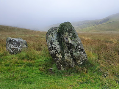
A
pair of standing stones, the "Buwch a'r Lo" (literally "cow and calf")
bore witness to the ancient origins of the route, which climbed again
from there to the little lake at Blaenmelindwr. At last the dampness
eased.


Just
beyond a second lake at Pendam I crossed the last high ridge of the
whole journey, and ahead the sky shone pale blue. Finally my first view
of the sea!
From a little further down, the cleft which contains Aberystwyth came into view, still nine miles or so to go.

A
long descent took me through some unremarkable villages to the edge of
the town, where a long route through a park avoids busy roads right into
the town centre. Five minutes or later I was at the destination hotel
right on the Promenade.
The
job is done - even though my legs were quite prepared to keep going! It
was, after all, only 3pm, and today's journey was just 14 miles. But -
time to stop.
My
wife arrived five minutes after I did, after driving from London, and
we have spent the time exploring the town. Its reputation isn't great,
but on first trek round, it exceeds expectations.
Fitting that the journey should end with a sunset over the Irish Sea...

More reflections to follow when my head slows down.
Once again, the route map shows the original plan, my actual route runs north of the A44. The mileage is much the same.

First reflections
Just one day after completing the journey, here are some first thoughts.
Let's get the easy part done first. Both before I set out, and along the way, I've been asked several times why Aberystwyth was my destination. If you followed these words from the start you'll know that it was something nerdy to do with the A44 road, and like many others I had no special expectations of the town. It has surprised us both. It has had a bit of a spruce-up, and what was previously quite tawdry is looking bright and fresh. The magnificent Promenade is probably its best-known feature.
Let's get the easy part done first. Both before I set out, and along the way, I've been asked several times why Aberystwyth was my destination. If you followed these words from the start you'll know that it was something nerdy to do with the A44 road, and like many others I had no special expectations of the town. It has surprised us both. It has had a bit of a spruce-up, and what was previously quite tawdry is looking bright and fresh. The magnificent Promenade is probably its best-known feature.

The cliff railway offers superb views across the town and over Cardigan Bay.

And buried down in the town there are now some great independent shops and a string of adventurous places to eat. In some ways it's still old-fashioned seaside, and the beach is uninviting granite grey sand, but it's worth a visit.
Perhaps not over 240 miles on foot though...
As to the journey. Was it worth it? You bet. What an experience! Obviously I've seen places which can only be discovered on foot, and I've watched the landscape gradually change along the way. It's sometimes been tough, sometimes frustrating, but mostly just amazing. I'll not easily forget the Chilterns, the Cotswold tops, the huge vistas from Bredon Hill, Hergest Ridge, or the drove roads around Radnor. Even the Cambrian wildernesses in the rain.
I've been asked if it was lonely: I'd rather call it solitary, occasionally daunting, all in a positive way.
Physically - by the time I reached the end I could have gone on and on. The thought of getting out of bed for another 20 miles with a full pack was no longer any concern. I feared I might have to worry about legs and feet - especially feet - but I had no problems.
Would I do it again? Not the same route, no, but a similar trek, yes. Not straightaway, these things take a long time to plan. For now I'll be happy to keep up a decent weekly rate, perhaps 50-60 miles a week, just to maintain the engine.
Just not over the next few days, which are earmarked for serious indulgent relaxation.
In the next week or so I'll check the exact route I followed, rather than the one I planned, to confirm the actual distances and ups and downs.
And there may well be more thoughts to come on here...
Route statistics
Here's the final route on a map:

Now
back in London, I've had the chance to click through the entire route
once more, this time including all the diversions I made along the way.
Up to the last two walking days in Wales, where the weather obliged me
to move completely from paths to roads, those diversions were mostly
about avoiding untrustworthy sections of footpath.
Overall the changes from the planned route made very little difference to the mileage, or to the ups and downs. Total mileage was 245.7, about four miles further than the original plan, while the total ascents were a tiny bit less, at 22,130ft. Still quite a mountain...
Here are the route statistics in detail:

Here's the final route on a map:

When I look back at that map I still find it quite hard to believe - all those days!
Overall the changes from the planned route made very little difference to the mileage, or to the ups and downs. Total mileage was 245.7, about four miles further than the original plan, while the total ascents were a tiny bit less, at 22,130ft. Still quite a mountain...
Here are the route statistics in detail:

For the gear bunnies
In
preparation for this trip I spent a great deal of time researching, and
quite a lot of money testing and selecting all the right gear for the
job. Here are the main items:
Footwear
- always a very personal choice. I tried a few options but settled on
Merrell Moab 2 Goretex walking shoes. Some reviews talk about leakage
and slipping on wet surfaces, but I didn't experience that. I chose
shoes rather than boots for light weight and flexibility - and also
found that I needed to go up an extra half size once I put a backpack
on.
Socks
- I now have a good collection... It is critical to get these right. My
final preference was for SmartWool PhD, which with over 60% merino wool
proved exceptionally comfortable all the way. Well worth the price.
Clothing
- I took a selection of sports t-shirts, all of which help perspiration
to disperse, also a Rohan Core Silver ziptop, great for the evenings.
My walking trousers were also Rohan, excellent design with pockets in
all the right places. I paid quite a lot for my Berghaus Paclite jacket
and overtrousers (together less than 500g) but in the Welsh rain they
proved themselves brilliant.
Backpack
- An Osprey Aether AG 70. There's just no comparison. With around 11kg
on my back I frequently forgot I was carrying it at all. Again not
cheap, but so well worth it. I added an Osprey Daylite day pack for the
rest days, and the hydration kit which works with both.
The obvious conclusion is that it would be a great shame not to make more use of all this kit. I shall. Watch this space...
No comments:
Post a Comment