In this page you will find the diary entries made each day during the Go West Walk to Bristol and Barnstaple in July 2022. They have been moved from the live posts area of this site to make room for new adventures...
Go West, they said...

Here
comes another journey. Over the last two years plans have been
constantly disrupted by the pandemic and by other matters, but now my
feet will soon have their marching orders. These things have to be done
while they are still possible.
Part
of the family suggested that this time I should go west, although I
resisted the idea of continuing as far as Cornwall. Once again this will
be a walk which will start from my front door in North London, and will
use nothing but legs to reach its destination. The first part of the
journey will take me to Bristol, but beyond there I looked at four
options: south into Devon, to Exeter or Plymouth, west across Exmoor to
Barnstaple, or over the Severn Bridge into Wales, then either south and
west to Tenby or north-west to Aberystwyth.
Finally Exmoor and Barnstaple won. The route goes over the Chilterns to join the Ridgeway, which I can follow to ancient Avebury. From there I shall go south to the highest chalk hills in the country around Tan Hill, before going west again towards Lacock, skirting Bath to the north to land in Bristol, around 150 miles and taking a week. From there the route goes over the Mendip Hills to Cheddar, west to Bridgwater and Dunster, then over Exmoor to Exford and on to Barnstaple for the train home, another five days and just over 100 miles.

I had originally thought to set out at the end of August, just as in 2019, taking advantage of fairly settled weather and the end of the family holiday season, but for various good reasons the trip is now set to start at the beginning of July, a couple of weeks after my 73rd birthday. It may be hot, it may be wet, we shall see. The earlier timescale puts some pressure on me to get my ageing body into gear and train, for just at the moment I would struggle to cover 21 miles with a full pack every day for days on end. The training can be done.
Just as before the accommodation will be in hotels, pubs and B&Bs, chosen to fit the necessary locations. Experience has taught me to pre-book every stop: I am too ancient now to be disappointed and sleep in a hedge. Just as before, this blog will record a little entry for each day during the trip.
For this year to date things are looking good: after months of mud and mess all the most enjoyable local routes are finally dry and fully open. I passed my first 1,000 miles on 21st April, almost exactly the same as in 2021, and I am averaging just over nine miles a day in the year so far. None of it is giving me any physical grief; the motor is on form...
Train, train, train

The least I can say is that I know how the training feels. As I am of a certain age, it does take some organisation. My training plans build on the walking that I do every day anyway, firstly to increase the distance I am covering comfortably. By the end of April I was happy to see 16, 18, 20 miles come up on the pedometer. The next stage is to begin all over again, but with a loaded backpack. I started this part in early May, a couple of months before the trek is due to begin. I have to admit I got the very first part wrong – I built up too fast from 5 miles to 12, and I put a little too much weight in the pack. Coupled with not having adjusted all the straps absolutely correctly, I ended up with some pulled muscles. Over time, and it takes time, these problems have settled down, and I am confident now of 20-mile days with a full load. There are still, with two weeks to go, some opportunities to prove that to myself. Normally I would expect to be fully ready in time to have a week of relaxation before departure, but a busy calendar and some very unseasonal weather, from far too hot to soaking wet, have combined to take days out of the schedule. No rest for the wicked. That’s life, I’ll be ready!
As I switched dates for the trip I have reconfirmed all my booked stopping points: I will not forget arriving in Broadway during the trip to Wales to find that my room upgrade had been misread as a cancellation – luckily a room was still available. I have also checked that I would not be stuck in Barnstaple if current industrial problems on the railways dribble on into July. Believe it or not, there is a direct coach service back to London.
The last bits and pieces have been ordered – they are few, as previous trips have left me with pretty much all I could need – and the final planning is being sorted out. This may be the last post here before the journey gets under way.
Day One - Finchley to Latimer - Wednesday 6th July
Finally the journey is under way. All the worries about
fitness and readiness swept away, and all the planning coming into
action. I knew that the first day, at just over 23 miles, would be a
challenge, but it all went very well.
The trip began as all previous trips, and hundreds of training walks,
also began, taking a route from home to the Dollis Brook bridge, the
brook sadly depleted after much dry weather.

From there I headed towards Mill Hill, then Totteridge, taking in the steep climb up "path 24" to Totteridge Green, then down to the London Loop path and a series of roads to cross the A1 at Stirling Corner.


Into Hertfordshire then, by roads and paths to Aldenham Country Park, where hopes of a quick lunch were dashed by an upgrade of the old café to a smart restaurant serving a full menu.


I passed by Elstree aerodrome, the air filled with the clatter of helicopters and the whiff of kerosene, then crossed the M1 and risked a path which had defeated my friend and me in 2019, and today it defeated me again. Luckily the diversion had a food shop on the way into Bushey.
The long traffic-ridden drag into Watford and out again is eased by the peaceful linear stroll through Oxhey Park, otherwise boredom rules to West Watford.

Here the psychology played its part. I had to walk past the hotel where i had ended day 1 of the journey to Wales, knowing that I still had almost eight more miles to go...
From here the route mirrored the second day of the journey to Wales three years ago, slogging through residential areas to Croxley Green, then escaping to field paths to join the Chess Valley Walk.

This route follows the eponymous river westwards to Chesham. In parts it is delightful, in others just tedious, especially near the crossing of the M25 motorway. Kissing goodbye to that particular traffic hell at least meant that all of London was now behind me.


I followed the marked path to Latimer to my first overnight stop. There is something exquisite about arriving in a very smart spa hotel carrying a backpack... It's a little over budget, as was the delicious dinner, but not all my stops will be like this!

Day Two - over the Chilterns to Ibstone - Thursday 7th July


Today at least there was no shortage of human company along
the way. Yesterday I had seen - and sometimes been grateful for -
temporary route markers along the Ridgeway. Today it all became clear.
This was the first day of the "Race to the Stones", a 100km ultra-run
from Lewknor to Avebury, following the Ridgeway. How the runners had
coped with the steep ups and downs I had crossed yesterday was clear
from how they looked coming through Goring.
I strolled to a shop to buy something for lunch, then headed west, back
over the Thames to Streatley, then on roads for a couple of miles before
the Ridgeway began its long climb upward.


Here the retrospective views improve as altitude is gained, and eventually the shape of the day to come is clear.


The Ridgeway track goes on and on, with
widening vistas on either side. The runners also went on and on, but
they did not show much interest in what was around them.
Parts of the track are just wide paths, some are broad, some are more or
less roads, but the route taken by the ancients across these hills
carries on regardless


It crosses the thundering traffic on the A34 in a tunnel, it looks down on the huge Harwell science campus, and all the time it rises and falls with the shape of the hills.
As the day edged from warm to hot I reached welcome shade at Scutchamer Knob, an Iron Age round barrow.


There's a memorial obelisk to Robert Lord Lindsay, Earl of Wantage, installed by his wife in 1903, and the ancient fort at Segbury.


At about 18 miles, with just four to go, there was a very welcome drinking water tap. I refilled my reservoir with lovely cold water.
Approaching White Horse Hill the track switchbacks for a while, uncomfortable in what by now had become a very hot day.
I left the Ridgeway near the top of the hill to follow a path downhill towards my destination.


Given the heat built into today's weather forecast I made a
change to the first part of my route, cutting out a dogleg south which
would have involved some steep climbs and more time on shadeless tracks.
It probably only took a couple of miles off the day's distance.
I paused in Avebury for another quick look at the stone circle, then
followed a route shown on the map as "The Wessex Ridgeway", sadly not as
well maintained as the national trail.


It passed by a pair of standing stones known as "The Long Stones", apparently all that remains of a mile-long celebratory avenue of stones going right up to the main circle.

All of this infrastructure dates back 2,500 years, so I suppose it has an excuse not to be complete.
The Wessex Ridgeway follows the main A4 road for a short while before
heading off diagonally to climb a ridge, at first through trees, then
out in the sunshine again.


The track, rather overgrown in places, is marked as the "Old Bath Road". The landscape here is still very much chalk downland, but with a more compact feel than the grand ridges and vistas of the last two days.
A turn southward took me steeply up to the Iron Age fort at Oldbury, with the obelisk of the Lansdown Monument beyond it.

The slender column was erected in 1845, and was apparently designed by the man who created the Houses of Parliament. Maybe in his spare time.


The path descended to join another track, a Roman road according to the map, which inevitably ran very straight, gently uphill with fine views behind to the downs.


Eventually my route left it to go back downhill across a golf course. Some paths do, despite the risk of a ball in the ear...
From meeting two men walking their dogs near the main road to a cheery
wave from two ladies on the golf course I saw not a single soul in about
five miles - such a contrast with previous days.
Dry hot dusty tracks led me to the village of Heddington, where I ate
lunch in the churchyard, warding off some curious chickens.

Long stretches of road followed, but at one point I checked my route plan and found that if I kept going I could reach a pub before it closed. There's nothing like a real incentive.
I passed through the hamlet of Sandy Lane, all cute thatched cottages almost deliberately hidden from view, and cameras, then followed a long (long) road, thankfully mostly under trees, to Bowden Hill. The buildings of Bowden Park, a 17th-century house rebuilt in the 1790s, and messed about several times since, run out into the road.

The entire 1,450 acre estate, with all the buildings, was recently on the market for £35 million. A place in the sun anyone? There was plenty of heat today!


The church of St Anne, linked to the house, is a little way down the hill, but so, more importantly, is the "Rising Sun". Never was a pint more welcome.

A little over a mile further, the road crosses ancient Lacock Bridge, then reveals a view of Lacock Abbey before arriving in the tourist honeypot village.


The abbey has been a residence since the 16th Century, but its claim to fame is as the home of William Fox Talbot, who in 1835 is reputed to have created the world's first photographic negative, an image of one of the abbey windows.
The whole village is now in the care of the National Trust, and even on a hot Monday it was very busy.


My route wandered west through the lanes to Gastard, where the smell of cows on the air was compensated by some pretty cottages.

Finally to the outskirts of Corsham, a straggling town for which I had few expectations, but it defied me. The magnificent Almshouses on one corner were followed by a pleasant old town centre.


Sadly it did not last long, but now I was only a mile from my destination, reached by a very well-tended footpath.


Day 8 was a rest day for me in Bristol, so the blog took a break as well.
Back to work this morning however, heading down to Bristol city centre
on the colourful and lively Gloucester Road, then on to the Floating
Harbour at Prince Street Bridge and the MShed museum.


The busy centre is soon left behind, going south over the Avon on a footbridge and once more into the suburbs.
About three miles further, the houses suddenly came to an end, and my chosen road lurched steeply uphill, rising about 500 feet in a series of curves to Dundry Hill, with a fine retrospect of Bristol, now left far behind.

Over the hill I was teased with a fine view over Chew Valley Lake...

...before facing a slog along a surprisingly busy road to Chew Stoke, not much of a place to rave about, except for one delightful corner.


I left the traffic behind to follow a very quiet little lane uphill, to a superb spot to eat my lunch.


From here, more lanes, downhill to Plaster's Green, past Blagdon Lake without being able to see one drop of it, and up to Ubley, crowned by a handsome church.

Ahead was the climb to the top of the Mendip Hills, using a track known as Ubley Drove. It was stony, steep and unrelenting, but it completed the climb from Blagdon Lake at 150ft to the top of the limestone plateau at 900ft in very efficient form.


More ascent on lanes took me in a couple of miles to the isolated Charterhouse Church, an odd building which looks like a farmhouse with a spire on top.

Just past the church I joined a track which would take me eventually to the road into Cheddar, and would do so without meeting a single soul on the way. The track descended past all that is left of the old lead workings, then threaded its way through a valley known as Velvet Bottom. No comment needed, but it was very attractive.


Finally to Cheddar Gorge. The local authority does its best to send walkers away from the road on to steep diversions, but I was not to be swayed. Typically I've driven through the gorge catching only a brief glimpse of the scenery, so the opportunity to take it all in at walking pace, even while avoiding lunatic drivers, was not to be missed.
I'll end this Cheddar write-up with a few of the pictures from that stroll through the gorge.


As planned, I reworked my day to make it shorter and less
strenuous, in view of the forecast high temperatures. Instead of heading
towards the old town of Dunster then looping over the summit of Dunkery
Beacon, the very top of Exmoor, I worked out a more direct southerly
line, saving probably three miles in distance but over a thousand feet
of ascent.
I left Washford at 7.30am, missing breakfast which on Sundays was served
only at 9, and went south by Lower Roadwater then up a hill and through
the lanes which here mark the edge of Exmoor National Park to Rodhuish,
a tiny hamlet blessed with a little 15th-century church which began
life as a travellers' rest.


A little further on after being snowed with straw by a rather overloaded tractor trailer, I turned on to Stout's Way Lane, which goes up 500 feet in less than half a mile, but the views back towards the sea are worth the sweat.


Needless to say, as soon as the road crested the hill it headed down again, turning west into woods.


It was shady under the tall old trees for almost all of the next mile to Kingsbridge, the first hamlet in the scattered settlement of Luxborough.

The exit from Kingsbridge was up two short but cruelly steep hills, beginning a long but gentle climb through other parts of Luxborough then across the fields. Here at over 1,000 feet it was suddenly very windy, but at least the wind was cool.


At the curiously named Couple Corner my lane joined a larger road, which continued the climb, going more than 100ft higher than the best the Quantocks could offer yesterday, although there was not quite the same feel.
Now to the north I was teased by an excellent view of the rounded bulk of Dunkery Beacon (I'll get you next time!).

There was also a glimpse of Bossington Hill, hiding Minehead behind it.

A short way on, I had a chat with a tractor driver, and as we discussed routes he gave me an idea which could mean a change of route tomorrow as well.
I left the road and headed down a track known as the Hare Path. The name is more likely to be from a Saxon word for "old" rather than anything to do with speedy big-eared mammals, just like the Herepath I walked a week ago reaching Avebury.

From the path the landscape to the west, in my direction of travel, came into view.

I crossed one of Exmoor's few main roads, close to the village of Wheddon Cross, then took a lane which pitched down steeply to cross the dribbling River Quarme, and of course you can guess what came next. What goes down must always go up again...
This time Thorne Lane began steep but was then satisfied to keep rising more gently, which it does for almost three miles.

Partway along I had the choice of avoiding about half of it, and an extra mile of main road, taking instead a route which went downhill, only to climb sharply back up again. I stuck with the more tedious simple option.
A couple of miles along a B-road, thankfully not too busy, brought me to Exford church and finally to the village and my stopping point for tonight.

My journey, I reckon it was about 15 miles, had taken me a little over five hours, and I was eager for some lunch.
Exford - pronounced with equal stress on both syllables - bills itself as a centre for Exmoor. It stands 850 feet up, has two pubs, a service station ("Land Rovers a speciality"), and a very large community store known as "The Exmoor Stores". There was great cheer when that reopened after the pandemic.

As the name suggests, the village straddles the River Exe, only about seven miles downstream from its source.

I am working on tomorrow's route with a very early start in mind, and by taking the tractor driver's advice I can trim it by about 3 miles. As the forecast is now for temperatures around 33-34 degrees from about 2pm, so it makes sense to plan to arrive before then.
It was less of a struggle than expected to set out from Exford really early - I left just after 6am, crossed the bridge and took to the long straight B-road towards Simonsbath, just over 5 miles away.

There was, as hoped, hardly any traffic, and the early morning light did its best to enhance the rather limited scenic opportunities.


What was slightly disconcerting was the complete disappearance of any mobile signal, not just along the road but for some miles beyond Simonsbath as well. How did we manage before?
Simonsbath is higher and a little wilder than Exford. Its little church bills itself as the "parish church of Exmoor".


Down the hill is the bridge over the River Barle, the current stone construction dated 1879 is the successor to many earlier crossings going back at least to the Middle Ages.


It should be no surprise that the road began to climb just beyond the bridge. There was another of Exmoor's higher ridges to cross. The first climb lasted almost 1½ miles, with a very fine view of the Barle Valley unfolding as height was gained.

There is a cairn monument to John William Fortescue (1859-1933), described as a "military historian", although in fact the Fortescues owned large parts of Exmoor until the 1990s.

Beyond the cairn the road dipped for a while before climbing steeply again to Kinsford Gate, where Devon is entered, and at 1,534 feet the highest point of the entire journey.


I paused to take in the sudden wide vista over Devon, and to watch a very large bird of prey circling just above.

Very glad not to be on his menu I began the descent, very straight and just as steep as the upward climb.

At the Poltimore Arms, curiously named as the village of that name is a long way further south, I turned on to another straight road, thankfully much of it shady, and pleasant enough if unremarkable.


At around 10am I reached Brayford, which maybe should have had promise, but had little to offer. An old bridge crossed the River Bray, but there was no shop and no mobile signal - again. Here my route finally left the Exmoor National Park.

After crossing the Exeter to Ilfracombe main road my little lane began another climb. A gradual uphill slog would normally just be an annoyance, but now it was beginning to get hotter, so there was more of a challenge. Somewhere along the top of that particular ridge I caught sight of the sea for the first time, far in the distance, but an inspiration to keep going.

The hamlet of Gunn, just five miles from Barnstaple, presented a neat little church, and some equally neat cottages.


Another twenty minutes or so of straight and now rather hot road brought me to Goodleigh, yet another village with no shop and a pub which opens at very odd times. Not today, of course.

Now only a short distance separated me from journey's end, and, descending alongside the Yeo valley (there is more than one River Yeo...), I completed the 21 miles from Exford to Barnstaple just after 1pm, as hoped missing the fiercer heat to come during the afternoon.


Barnstaple is a mixture of chain shops, scruffy streets, smart streets and a shopping centre, and has the feel of a town larger than its 21,000 inhabitants might suggest. It is not on the coast, but stands at the confluence of the Yeo, which rises on Exmoor, and the Taw, with its source on Dartmoor, a long way to the south.


This will be the last on-the-go entry here, but there will be more to see once I return to London. Unless the unusual heat has bent all the railway tracks and disabled all the buses, that will be a journey for tomorrow.

Now back in London after a rather disrupted rail journey through unusually high temperatures, and a few days to gather my thoughts, it is fitting to look back on this trip. I have also had time to retrace my actual steps and work out the nerdy bits. Comparisons with other journeys are inevitable. This one, at 253 miles, was just over seven miles longer than the 2019 trip to Wales, and involved around a thousand feet more of ups and downs. It was very much a journey in two parts, either side of the Bristol rest day. The landscapes and terrain of the second part were very different from the dominant chalk downlands and broad vistas of the first.
Naturally it led to discovering places, corners, villages and scenes which are available only to the traveller on foot, which is one reason for doing it. Apart from the passing runners on days four and five, there were many miles where I saw, quite literally, no other soul. Those who claim our country is “bursting at the seams” should perhaps try a journey like this one. Travelling solo can be an absolute joy – you make your own decisions about the route, where to stop, how fast to go – but it also has its concerns. The traverse of the Mendips, for example, from Ubley to Cheddar Gorge, involved some steep and rough paths which seemed little used, in an area with no mobile phone signal. In fact absence of communications was quite an issue across much of the Somerset and Devon sections. All part of the fun.
For this journey the heat of summer was inevitably more of a challenge than for my earlier journeys. I got used to the build-up of heat in the afternoons, perhaps 28 degrees or so from mid-afternoon onward on many days, time to reapply the suncream and put on a hat. The exceptional heat of the last two days forced me to replan routes and to set out early, missing my usual big cooked breakfast (damn). It rained only once, on the way into Bristol, and only for about ten minutes. On the other hand there were no problems with muddy, flooded or impassable paths, everything was baked hard.
I stayed in a mixture of places, some claimed to be luxurious and were, some not, some had no pretensions but were delightful. There was an amazing variety of rooms, and some very different approaches to what should be found in them. I cannot remember a bad meal, which is unusual, and I can remember a number of very tasty local beers. Only in one stop was the stay compromised by poor service, but that will go into my review.
The next trip? Who knows. When I find out I will post the ideas here.
Statistics
Here are the details for each day. Mileages include only what was part of the route, ignoring extra distance for sightseeing or hunting down dinner.
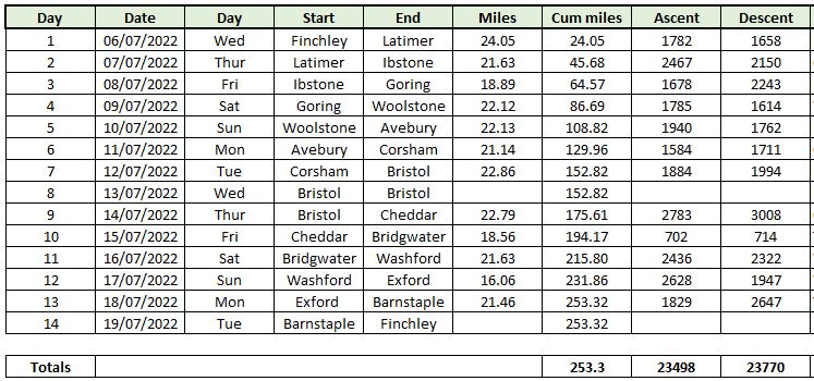
Average daily mileage was thus 21.1, slightly more than on the journey to Wales, but comparable with the walk to Suffolk in 2021.
For the gear bunnies
Much of my gear remained the same as for previous journeys.
For my load I use an Osprey Aether 65 backpack, and when fully loaded it wieghs in at 10-12 kilos depending on how much water I am carrying. For the water I use an internal reservoir so I do not need to stop or fiddle with water bottles, the one disadvantage is that there is no visibility of how much is left in it.
My
trusty Merrell Moab 2 GTX shoes carried me all the way. Apparently this
model has now been replaced by a Moab 3, which is claimed to respond to
the one problem with the Moab 2, a rather hard footbed under the toes.
We shall see. I paired the shoes with Smartwool socks, a mixture of my
favourite PhDs and their replacement, called a "Medium Hike". The new
version was less comfortable so I shall be back on research again soon.
Luckily I have enough of the discontinued version to last me a while.
Shoes and socks are a very personal thing, so this combination may not
work for everyone.
For
navigation I use Anquet maps, the OS maps at various scales up to
1:10,000, but I download to my phone all the areas I might need so there
is no problem with any connections in the wild. This also allows me to
plan a route at home and send it to the phone for active use. The GPS
tracking on the latest version of the Anquet app is much improved since
the 2019 trip, and did not crash once. I put my phone in a brick of a
case, and attach it to my waistband with a lanyard. Rather it bruised my
knee than crashed to the ground. I have one bruise... Just in case, I
printed the entire route on to double-sided A4 paper, but I had no need
of that
No comments:
Post a Comment